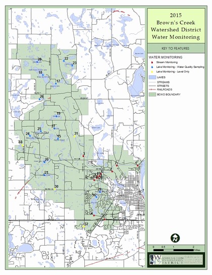
Water Quality Monitoring Locations
Brown’s Creek is monitored at Highway 15, McKusick Road, Stonebridge and the Creek Outlet.
BCWD monitors Masterman Lake, Bass Lake East, Bass Lake West, Lynch Lake North, Lynch Lake South, Jackson WMA Pond, July Avenue Wetland, Woodpile Lake, Pat Lake, Goggins Lake, Kismet Basin, Long Lake, South School Section Lake, Benz Lake, and Plaisted Lake.
Sediment and Nutrient Loading from Brown's Creek to the St. Croix River - Meeting Goals in 2021
The total phosphorus load from Brown’s Creek to the St Croix River in 2021 was 1,566 pounds (goal not to exceed 1,804 lbs/year), and the total suspended solids load was 69.47 pounds per acre of watershed land (goal not to exceed 74 lbs/year ), as determined by the Brown’s Creek Outlet station results.

- 2024 Baseline Monitoring Report
- 2023 Baseline Monitoring Report
- 2022 Baseline Monitoring Report
- 2021 Baseline Monitoring Report
- 2020 Trend Analysis Presentation
- Browns Creek and Long Lake 2020 Trend Analysis
- 2020 Baseline Monitoring Report
- 2019 Baseline Monitoring Report
- 2018 Baseline Monitoring Report
- 2017 Baseline Monitoring Report
- 2016 Baseline Monitoring Report
- 2015 Baseline Monitoring Report
- 2014 Baseline Monitoring Report
- 2013 Baseline Monitoring Report
- 2012 Baseline Monitoring Report
- 2011 Baseline Monitoring Report
- 2010 Baseline Monitoring Report
- 2009 Baseline Monitoring Report
- 2008 Baseline Monitoring Report
- 2007 Baseline Monitoring Report
- 2006 Baseline Monitoring Report
- 2005 Baseline Monitoring Report
